


| Raquette
Lake Section Main Route 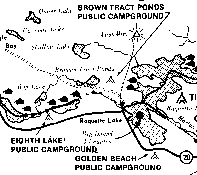 The
main routes divide at Raquette Lake. The route leading to Tupper Lake, the Saranacs,
Paul Smiths, etc. extends north through Raquette Lake past Indian Point, the Needles
and Bluff Point. From there, the route heads down Outlet Bay northeast to the
landing on the north shore of the bay, near the Raquette Lake outlet. It is 8.5
miles from Raquette Lake Village to the landing. A word of advice, it is wisest
to plan to cross Raquette Lake early in the morning. Another route ends at Blue
Mountain Lake. This route is described in the next section. coming into Raquette
Lake from Browns Tract inlet there is a small wooded island that lies dead ahead.
Keep left of the island and head for the opening between the next small island
and what appears to be the mainland (but is really Big Island). When in the narrow
channel between these two, bear right around a point on Big Island into a small
bay and to the leantos. Golden Beach Public Campground is located at the eastern
end of South Bay. To reach the shelters on Clark Point, start from the Browns
Tract Inlet, follow the left shore to and around Antlers Point and head west to
a point on the north side of Lonesome Bay where two leantos and a spring are located. The
main routes divide at Raquette Lake. The route leading to Tupper Lake, the Saranacs,
Paul Smiths, etc. extends north through Raquette Lake past Indian Point, the Needles
and Bluff Point. From there, the route heads down Outlet Bay northeast to the
landing on the north shore of the bay, near the Raquette Lake outlet. It is 8.5
miles from Raquette Lake Village to the landing. A word of advice, it is wisest
to plan to cross Raquette Lake early in the morning. Another route ends at Blue
Mountain Lake. This route is described in the next section. coming into Raquette
Lake from Browns Tract inlet there is a small wooded island that lies dead ahead.
Keep left of the island and head for the opening between the next small island
and what appears to be the mainland (but is really Big Island). When in the narrow
channel between these two, bear right around a point on Big Island into a small
bay and to the leantos. Golden Beach Public Campground is located at the eastern
end of South Bay. To reach the shelters on Clark Point, start from the Browns
Tract Inlet, follow the left shore to and around Antlers Point and head west to
a point on the north side of Lonesome Bay where two leantos and a spring are located.
From Clark Point to Outlet Bay, the course is generally northeast. Head through the narrows and around the Needles where a buoy is usually located. About 2 miles from Clark Point, on the east shore of the lake is Tioga Point, the location of fifteen leantos. These are in the same category as a public campground with a service charge and a caretaker on duty during the DEC's camping season. Bluff Point juts out prominently dead ahead on the eastern shore. The northeasterly course to Outlet Bay is evident after bearing right around Bluff Point. Rounding Bluff Point, the Boucher leantos are found on the north shore of Outlet Bay. After the bay begins to narrow, you will see a leanto sign on the north shore. From this point, it is a short mile to the old dock and a sign marking the carry to Big Forked Lake. |
| Forked Lake Section 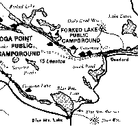 The
.5 mile carry from Raquette Lake into Forked Lake follows a road leading northward.
A phone booth marks where this carry crosses the North Point Road (County Route
13) that extends from North Point on Raquette Lake to Deerland. The
.5 mile carry from Raquette Lake into Forked Lake follows a road leading northward.
A phone booth marks where this carry crosses the North Point Road (County Route
13) that extends from North Point on Raquette Lake to Deerland. After putting in on the south shore of Forked Lake at the end of the carry, follow the shore eastward, past a leanto and proceed 3.25 miles to the outlet where a public campground is located. For tent sites see the caretaker. At this point, it is necessary to leave the water and carry for 1.5 miles down County Rt. 20, a dirt road. Be sure to keep left where the road forks one mile from the dam. Proceed past the rapids in the Raquette River to where the river becomes navigable for small boats. The Pine Brook Lean to is located here. After putting in, canoe about a mile downriver to the head of Buttermilk Falls. At the falls there is a carry of about .1 mile on the east side of the stream. After the carry, you can canoe for about .5 mile to a plainly indicated landing on the east shore of the stream. This carry is about .5 mile long and avoids the rapids. You can put back in near the two Deerlands lean tos about .5 miles above the head of Long Lake. |
| Blue
Mountain Lake Section Main Route 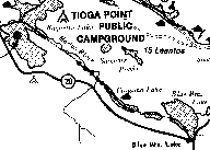 Instead
of going north across Raquette Lake toward Forked Lake, you can shorten your trip
and end at Blue Mountain Lake. To do this, start from Raquette Lake dock and set
a course that skirts the north shore of Big Island. From there, head northeast
around the tip of Long Point and then easterly into the winding Marion River.
Take the Marion up to the remains of an old railroad bridge where there is a carry.
(Distance from Raquette Lake Village to the carry is 6 miles). The .5 mile long
carry brings you to the dam near the foot of Utowana Lake. There is a leanto on
the north shore .5 mile beyond the dam. Canoeing through Utowana Eagle and Blue
Mountain Lakes for a distance of about 7 miles brings you to Blue Mountain Lake
village on the east side of Blue Mountain Lake. Instead
of going north across Raquette Lake toward Forked Lake, you can shorten your trip
and end at Blue Mountain Lake. To do this, start from Raquette Lake dock and set
a course that skirts the north shore of Big Island. From there, head northeast
around the tip of Long Point and then easterly into the winding Marion River.
Take the Marion up to the remains of an old railroad bridge where there is a carry.
(Distance from Raquette Lake Village to the carry is 6 miles). The .5 mile long
carry brings you to the dam near the foot of Utowana Lake. There is a leanto on
the north shore .5 mile beyond the dam. Canoeing through Utowana Eagle and Blue
Mountain Lakes for a distance of about 7 miles brings you to Blue Mountain Lake
village on the east side of Blue Mountain Lake. |
|
Long Lake Section Main Route 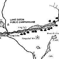 From
the head of Long Lake, proceed down for 4.5 miles to Long Lake Village. (Note,
this is the last opportunity to replenish supplies until you reach the Trading
Post at Fish Creek). Two Catlin Bay leantos are located about 2 miles beyond Long
Lake Village on the southeast shore of the lake. Look for a summer cottage that
stands out prominently on the southeast shore where the lake begins to widen.
Pass this and two other points that are not far apart and swing to the right into
a small bay. The first leanto is in view on the south side of the point. The other
leanto is just beyond, around the north point of the bay, just out of sight in
the woods. Numerous other leantos are also found on Long Lake: They are found
on the southeastern shore before you reach Round Island; two miles further, on
high ground overlooking the lake on the southeastern shore of Long Lake at Rodney
Point, and on the southeast shore at Plumbley's Landing; there is another one
at Plumleys Point, then seven more at Wilderness Camps on the northwest shore
opposite Island House Leanto. From
the head of Long Lake, proceed down for 4.5 miles to Long Lake Village. (Note,
this is the last opportunity to replenish supplies until you reach the Trading
Post at Fish Creek). Two Catlin Bay leantos are located about 2 miles beyond Long
Lake Village on the southeast shore of the lake. Look for a summer cottage that
stands out prominently on the southeast shore where the lake begins to widen.
Pass this and two other points that are not far apart and swing to the right into
a small bay. The first leanto is in view on the south side of the point. The other
leanto is just beyond, around the north point of the bay, just out of sight in
the woods. Numerous other leantos are also found on Long Lake: They are found
on the southeastern shore before you reach Round Island; two miles further, on
high ground overlooking the lake on the southeastern shore of Long Lake at Rodney
Point, and on the southeast shore at Plumbley's Landing; there is another one
at Plumleys Point, then seven more at Wilderness Camps on the northwest shore
opposite Island House Leanto. From Long Lake Village it is 9.5 miles to the foot of the lake where you enter the Raquette River. At approximately this point, you pass from Hamilton to Franklin County. |
Dining | Summer Sports | Winter Sports | Arts & Crafts | Attractions
Shopping | Adirondack Kids | Adirondack Lifestyles | Education
Business Profiles | Community Links | Business Directory | Classifieds
Adirondack History | Bulletin Board | Chat Room | Guestbook Comments | Return Home

Saranac Lake, New York 12983
Phone: 518-891-3745 Fax: 518-891-3768
E-Mail: Adirondacks.com
This website is
owned and operated by
adirondacks.com internet publishing group.
For
advertising and editorial content,
please contact Rob Grant;
adirondacks.com
reserves the right to reject,
modify or cancel any advertising at its sole
discretion.
© Adirondacks.com - all rights reserved