


| Raquette
River Section Main Route 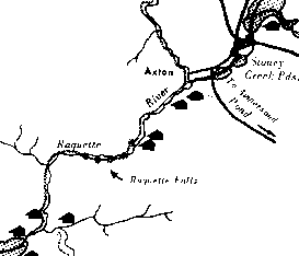 From Long Lake Village it is 9.5 miles to the foot of the lake where you enter
the Raquette River. Pay attention, the channel from the lake is tricky, especially
when the water is low. To the extreme right, boulders on the shore indicate a
channel that is impassable in low water. To the left of this channel is a long
marsh tipped by a sand dune that juts out toward the lake, the main channel is
to the left of this point, along the edge of a curving sandy shallow. Still further
to the left is what appears to be another channel - avoid it.
From Long Lake Village it is 9.5 miles to the foot of the lake where you enter
the Raquette River. Pay attention, the channel from the lake is tricky, especially
when the water is low. To the extreme right, boulders on the shore indicate a
channel that is impassable in low water. To the left of this channel is a long
marsh tipped by a sand dune that juts out toward the lake, the main channel is
to the left of this point, along the edge of a curving sandy shallow. Still further
to the left is what appears to be another channel - avoid it. Lost Channel comes in on the right, pass it by. A big oval boulder is seen ahead. The land beyond it is an island. To continue down Raquette River, take the channel to the left; the Deep Hole leanto is on the west bank of Raquette River at the mouth of Cold River. Take the right hand channel, turn sharp right again where Cold River comes in to reach Caulkins Creek leanto on Cold River. It is one mile upstream to the leanto on the left bank. On leaving this camp, follow the right bank downstream into Raquette below the island mentioned above. Travelers from the opposite direction often lose considerable time by mistaking where Cold River comes in at the north end of the island for the main branch of Raquette. Six miles below the outlet is the carry around Raquette Falls. Located on the east bank of the river, the carry is plainly marked. The trail goes along an old tote road for 1.25 miles to the foot of the falls where a leanto, a small clearing and the caretaker's cabin are located. About .5 mile below the foot of the falls, there is a leanto on the east side of the river, one at the junction of Palmer Brook, and another .5 mile below the junction of Palmer Brook. At the foot of the falls you may put in again and canoe 6 miles farther down the river to Axton. The Stony Creek leanto is located just above Axton, near the intersection of the outlet of Stony Creek Ponds and the Raquette. Approximately five miles below Raquette Falls the river makes its bend to the northwest in a broad reach. As one enters this stretch, three large boulders are prominent ahead on the right shore. The insignificant Stony Creek Ponds outlet comes in on the right, just upstream from these boulders. You can see a highway bridge up Stony Creek Outlet to the right. If you want to go to the Saranacs, follow Stony Creek Outlet as described in the Saranac section. If you want to go to Tupper Lake, follow Raquette River northeasterly toward Axton. |
| Tupper
Lake Section Main Route 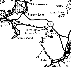 From Axton, the canoe trip down Raquette River is 18 miles long. There is a public
boat launching site at the Hamlet of Moody on the southeastern shore of Tupper
Lake. As the crow flies, it is about three miles from Axton to the Tromblee Clearing
leanto, but by canoe, the winding river covers 8 miles. A mile beyond this leanto,
there is a cutoff on the left. This cutoff of about 400 feet saves a mile long
paddle around the north loop where the river comes close to the state highway.
By following the left hand shore (south shore) and keeping sharp left, canoeists
will keep in the proper channel. From the Oxbow, the route is southwest until
Simon Pond is reached. Where the river bends sharply to the north, a cutoff heading
toward Mt. Morris leads to the southwest. Take this to Simon Pond and head west
for the Rt. 30 highway bridge. From this point, the channel is marked on the outlet
of Tupper Lake, then north to Raquette Pond and the dock at Tupper Lake Village.
Leantos are found at Black Bay and Sorting Gap. An alternate route is a six mile
side trip after entering Tupper Lake, to the south end. You can extend your trip
northwest out of Raquette Pond to the Piercefield Flow then down river all the
way to Massena and the St. Lawrence River.
From Axton, the canoe trip down Raquette River is 18 miles long. There is a public
boat launching site at the Hamlet of Moody on the southeastern shore of Tupper
Lake. As the crow flies, it is about three miles from Axton to the Tromblee Clearing
leanto, but by canoe, the winding river covers 8 miles. A mile beyond this leanto,
there is a cutoff on the left. This cutoff of about 400 feet saves a mile long
paddle around the north loop where the river comes close to the state highway.
By following the left hand shore (south shore) and keeping sharp left, canoeists
will keep in the proper channel. From the Oxbow, the route is southwest until
Simon Pond is reached. Where the river bends sharply to the north, a cutoff heading
toward Mt. Morris leads to the southwest. Take this to Simon Pond and head west
for the Rt. 30 highway bridge. From this point, the channel is marked on the outlet
of Tupper Lake, then north to Raquette Pond and the dock at Tupper Lake Village.
Leantos are found at Black Bay and Sorting Gap. An alternate route is a six mile
side trip after entering Tupper Lake, to the south end. You can extend your trip
northwest out of Raquette Pond to the Piercefield Flow then down river all the
way to Massena and the St. Lawrence River. |
Dining | Summer Sports | Winter Sports | Arts & Crafts | Attractions
Shopping | Adirondack Kids | Adirondack Lifestyles | Education
Business Profiles | Community Links | Business Directory | Classifieds
Adirondack History | Bulletin Board | Chat Room | Guestbook Comments | Return Home

Saranac Lake, New York 12983
Phone: 518-891-3745 Fax: 518-891-3768
E-Mail: Adirondacks.com
This website is
owned and operated by
adirondacks.com internet publishing group.
For
advertising and editorial content,
please contact Rob Grant;
adirondacks.com
reserves the right to reject,
modify or cancel any advertising at its sole
discretion.
© Adirondacks.com - all rights reserved